You may have been to Hooker Falls in DuPont State Recreational Forest, but this hike gives you the chance to explore an old favorite from a new route. This part of the challenge will take you to Hooker Falls via Holly Road, then the new Hooker Falls Trail. White Squirrel Hiking Challenge participants will start at the Lake Imaging Access area and hike Holly Road to the Hooker Falls Access Area. This hike is an approximate 3.6 mile round-trip trek.
With over 90 miles of interconnected trails, DuPont is a fantastic place where new adventures abound. The new Hooker Falls Trail is a sustainable reroute to Hooker Falls in DuPont State Recreational Forest that opened in 2020. Our very own Trails Specialist Peter Barr provided his trail expertise in the design of this new, sustainable reroute of the original Hooker Falls Trail. Conserving Carolina played an integral role in the creation of DuPont State Recreational Forest and continues to participate in its conservation and expansion.
This hike is part of Conserving Carolina’s and WPA’s White Squirrel Hiking Challenge 6, which takes you to 8 amazing hikes on protected land. Take the challenge to discover some great places!
Route: Lake Imaging Access Area to Holly Road to Hooker Falls Trail
Length: 3.6 miles round-trip
Difficulty: Easy to moderate
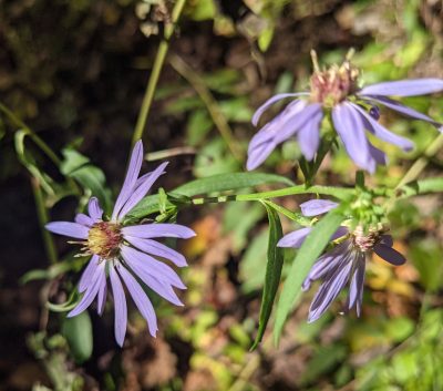
Great For: Waterfall, Wildflowers, Wildlife
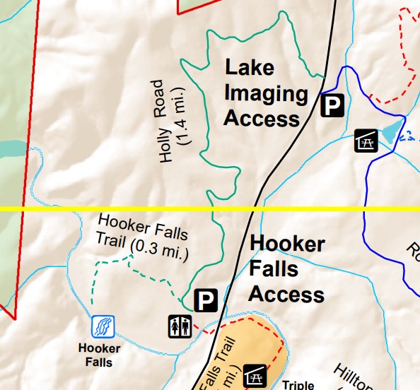
Trail Map for DuPont State Forest
DuPont provides this trail map, which you can download or print before your hike. Here’s a detail of the area for this hike.
How to Get to Lake Imaging Access Area
The Lake Imaging parking lot is located off Staton Road in DuPont State Recreational Forest, in Transylvania County. GPS users may enter N35.208918, W-82.615257 in their units.
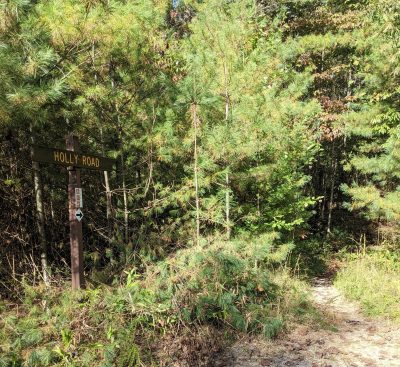
Holly Road is located across Staton Road from the Lake Imaging Parking Lot approximately 280 feet north of the parking lot entrance at 35°12’36.2″N 82°36’55.8″W. Participants will have to cross Staton Road to get to Holly Road. Use extreme caution when crossing the street, as it can be a busy road and there is no formal crosswalk.
DuPont’s parking areas fill up on many weekends. We recommend arriving before 9AM or after 4PM if planning on a weekend hike. There is more parking availability on weekdays as well. There will be no roadside parking once lots are full.
Hiking Holly Road to Hooker Falls
The Holly Road to Hooker Falls trek is an approximate 3.6-mile round-trip, out-and-back hike in DuPont State Recreational Forest that is easy to moderate with an approximate 300 feet in elevation gain.
Please be prepared. Bring water and snacks. You will be under tree shade much of the hike, but you may need protection from sun and insects, so bring layers, bug spray, and sunblock. This hike is appropriate for pets and children, but pets must be leashed in DuPont State Recreational Forest.
After parking at the Lake Imaging parking area, you’ll need to cross Staton Road to begin the trail. Walking along the path on the side of the road, head approximately 280 feet north of the parking area to reach the unmarked trailhead.
The trail begins as an uphill, single track flow trail into the forest. At approximately, 0.1 miles, the trail flattens and widens into an old road bed. The trail meanders through the forest with slight gains and losses in elevation. It is a wonderful, gentle walk through the woods on alternating natural and gravel surfaces. There may be wet spots in the trail following significant rain events. (If possible, walk through these muddy areas. Walking around mud in a trail increases the width of the trail and increases the impact of the trail on the forest.)
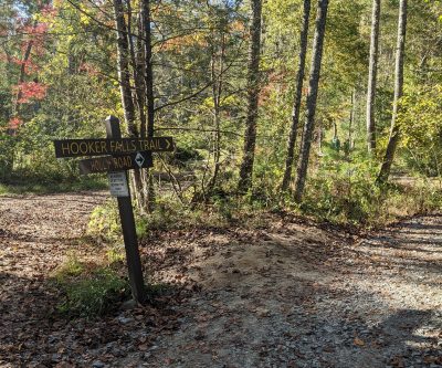
Holly Road is approximately 1.4 miles long. Towards the end, the trail becomes a gravel road and continues straight, veering slightly to the left. This brings you to the Hooker Falls Access area, where you can turn left to head down to the parking lot for a bathroom break. Otherwise, you turn right to continue onto Hooker Falls Trail.
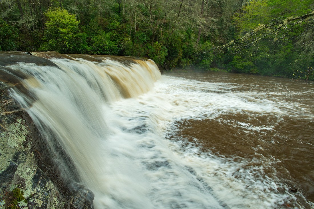
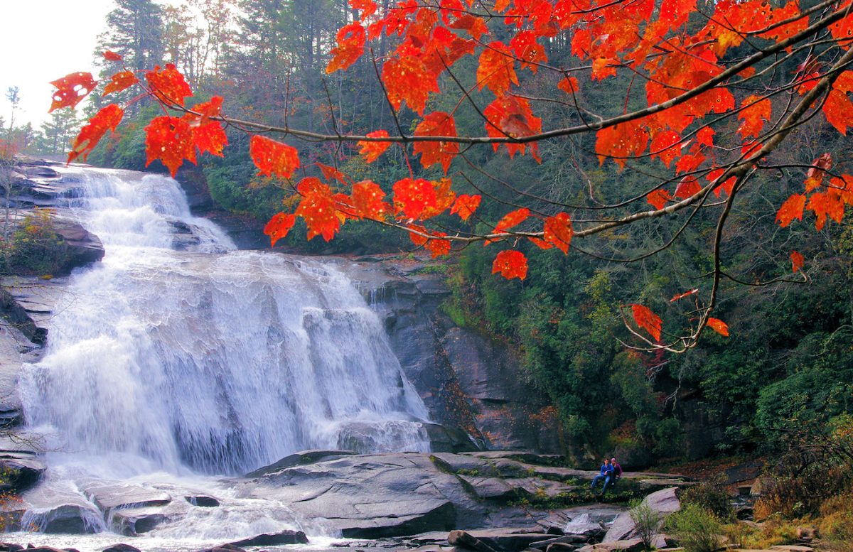
Hooker Falls Trail is a 0.6 mile round-trip gravel path. It leads down into Hooker Falls at a potentially steep incline. If bringing children or pets, be cautious, as part of the trail has a steep drop off on one side. Shortly into the trail, you’ll see fencing that blocks access to a cemetery in the distance, off-trail. Please respect trail boundaries and do not go off trail to investigate. When you arrive at the bottom of the trail, follow the sound of rushing water to the falls, which will be on your left.
This challenge is an out-and-back hike. When you reach the endpoint at Hooker Falls, enjoy the waterfall. Bring a picnic, a blanket, and your water gear. Use great caution around waterfall, bearing in mind that waterfalls can be deadly and there are injuries and fatalities at DuPont’s waterfalls each year. When you are ready, turn around and hike back the way you came. The way up from Hooker Falls back to Holly Road is a steep incline. Take your time on the return trip.
Hooker Falls Trail Ethics
- DuPont State Recreational Forest is open daily from 5AM to 10PM.
- Pets must be leashed and under control at all times.
- Remove all waste, including pet waste.
- Trails are multipurpose. Practice good trail sharing etiquette.
- No e-bikes or motorized travel are allowed.
- Stay on the trail at all times.
- No camping or campfires.
- Areas or trails designated “No Entry,” “Do Not Enter,” or “Authorized Personnel Only” are prohibited to trail users.
- Alcohol and illegal controlled substances are prohibited.
- No collecting of any flora, fauna, rocks, or any other natural items.
- Park only in designated spots only.
Conserving Carolina and DuPont
DuPont State Recreational Forest is a 12,000-acre wooded wonderland bursting at its seams with spectacular waterfalls, scenic granite domes and inviting backcountry. An outdoor enthusiast’s paradise, it offers nearly 90 miles of hiking, mountain biking, and equestrian trails to explore its charming beauty. Rolling hills tucked between high mountains peaks host the upper reaches of the Little River and six of western North Carolina’s most stunning waterfalls.
Thanks to its beauty and ample accessibility, DuPont is among the state’s premiere outdoor recreation destinations. Among waterfall enthusiasts, DuPont’s falls consistently rank as the most impressive in all of North Carolina.
DuPont’s story represents a landmark achievement for land conservation in western North Carolina. With Conserving Carolina as the catalyst, the first 7,600 acres of what became DuPont State Recreational Forest was purchased by The Conservation Fund, then by the state of North Carolina, in 1996. DuPont has since grown to more than 12,000 acres.
Over the years, Conserving Carolina has helped make numerous additions to the forest, including the new Continental Divide Tract, once known as the “missing link.” Protected in 2018 and conveyed to DuPont State Recreational Forest in 2019, this property connects DuPont to a conservation corridor that spans more than 100,000 acres along the North Carolina / South Carolina border, with exciting potential for future trail connectivity.
Complete the White Squirrel Hiking Challenge 6
This hike is part of Conserving Carolina’s and WPA’s White Squirrel Hiking Challenge 6. This challenge takes you to 8 amazing places that Conserving Carolina helped protect or open to the public. They are there for you to enjoy so get out and explore them! The challenge takes you to the highest waterfall in the eastern U.S., new trails in the Hickory Nut Gorge, and much more. Check out all eight hikes!
The challenge is sponsored by Witherspoon Platt and Associates, a conservation focused real estate firm. We are grateful for their strong support of conservation!
![]()