Update: Strawberry Gap Trail is currently open. Among other trails in the Gerton area, Florence Nature Preserve and the lower part of Wildcat Rock Trail remain closed due to damage from Hurricane Helene and restricted roads. Bearwallow Mountain Trail is open, but Bearwallow Mountain Road through Gerton is still restricted. Please do not drive through Gerton to reach the trailhead for Bearwallow Mountain and Trombatore Trail. Trombatore Trail is open. The Wildcat Rock trailhead is closed, but you can access the upper part of Wildcat Rock Trail from the upper endpoint of this trail on Bearwallow Mountain.
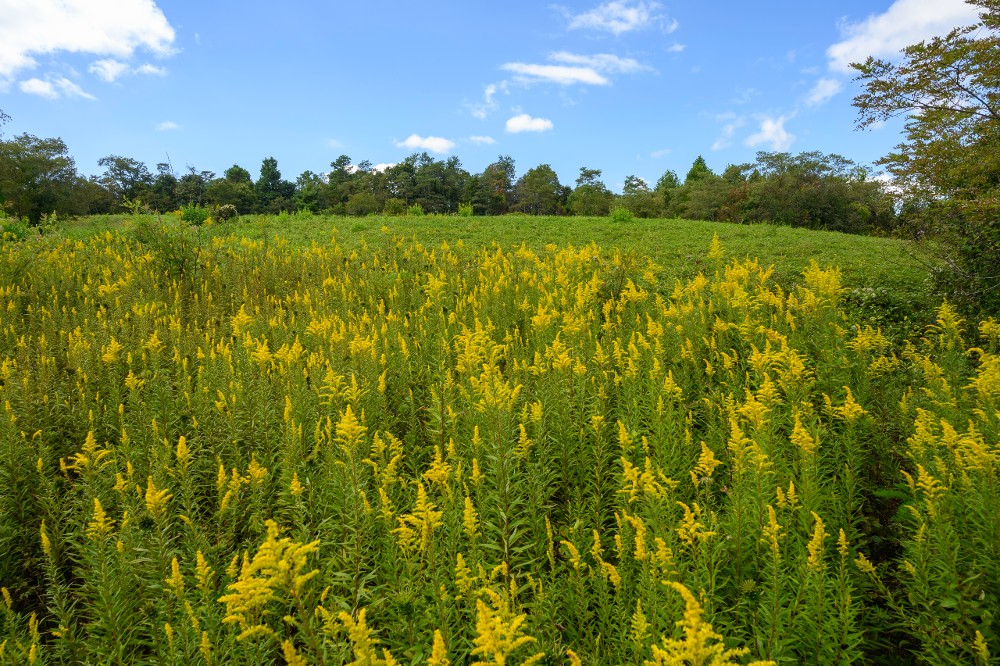
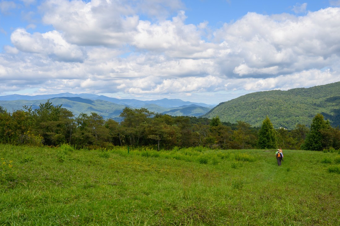
Strawberry Gap is the newest trail in the stunning Upper Hickory Nut Gorge trail network–opened in September 2022. The trail climbs upward for three miles through beautiful, boulder-strewn forests. About halfway up, a rock outcrop offers sweeping views over a picturesque valley and range upon range of distant, blue mountains. The climax of this trail is Blue Ridge Pastures, where the forests give way to a ridgeline pasture, revealing dramatic views of the Hickory Nut Gorge, Bearwallow Mountain, Little Pisgah Mountain, and in the distance the highest mountains in the eastern United States.
This trail is made possible through a partnership between two local land trusts–Southern Appalachian Highlands Conservancy (SAHC) and Conserving Carolina. SAHC owns Strawberry Gap Preserve and worked with multiple private landowners to protect this beautiful mountain land with conservation easements. Conserving Carolina then built the trail, which connects to Trombatore Trail at Blue Ridge Pastures. This brings us to more than 16 miles of connected trails in the Upper Hickory Nut Gorge!
Please note that Strawberry Gap passes through privately owned land and dogs are not allowed on this trail.
Length: 6 miles out-and-back. See below for more hiking options.
Difficulty: Strenuous
Great For: Hiking, Views, Photography, Wildflowers, Trail Connections

No Dogs Allowed on Strawberry Gap Trail
![]() This trail crosses through private property, thanks to the generosity of the landowners. Please respect this private protected land by following all of the trail rules including that dogs are not allowed. If you want to hike with your dog, there are many other options for you in the Upper Hickory Nut Gorge. Dogs are welcome on nearby Conserving Carolina trails, including Trombatore, Bearwallow, Wildcat Rock, and Florence Nature Preserve. If you are hiking one of these trails, please note that dogs must always be on leash and you must pick up and carry out all pet waste. Learn more about hiking with dogs on our trails.
This trail crosses through private property, thanks to the generosity of the landowners. Please respect this private protected land by following all of the trail rules including that dogs are not allowed. If you want to hike with your dog, there are many other options for you in the Upper Hickory Nut Gorge. Dogs are welcome on nearby Conserving Carolina trails, including Trombatore, Bearwallow, Wildcat Rock, and Florence Nature Preserve. If you are hiking one of these trails, please note that dogs must always be on leash and you must pick up and carry out all pet waste. Learn more about hiking with dogs on our trails.
Finding the Trailhead and Parking
The Strawberry Gap trailhead is located in Gerton, NC. It is on the south side of Highway 74A, near its intersection with Little Pisgah Road. You will see a fenced gravel parking area with space for 25 cars and a kiosk at the trailhead.
The GPS coordinates for the trailhead are: 35.4877 -82.3557
Park Only in Designated Parking Spots
Please do not park outside of designated spaces. Vehicles parked outside of designated areas will be towed at the owner’s expense. If the parking area at Strawberry Gap is full, consider hiking at one of the nearby trails such as Trombatore, Bearwallow, Wildcat Rock, or Florence Nature Preserve.
Alternate Access from Bearwallow/Trombatore Trailhead
Strawberry Gap connects to the Trombatore Trail at Blue Ridge Pastures. If you are interested in a longer hike or a shuttle hike, you can start at the trailhead shared by the Bearwallow Mountain and Trombatore Trails. See how to find this trailhead. You would reach Strawberry Gap Trail after hiking the 2.4-mile Trombatore Trail.
Create More Places to Enjoy the Great Outdoors!
If you enjoy places like Strawberry Gap, become a member of Conserving Carolina! We’re always working to create new parks, trails, greenways, and nature preserves. Your membership supports conservation and we’ll keep you in the loop about the latest news, outings, and events.
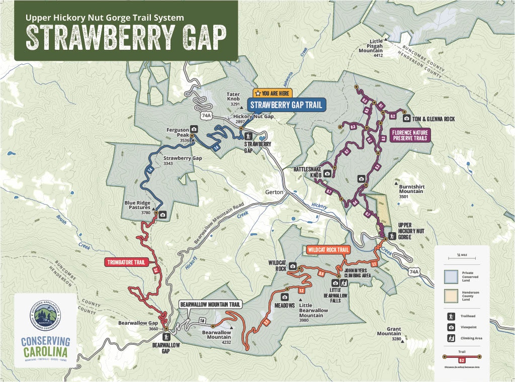
Map of Strawberry Gap and Upper Hickory Nut Gorge Trail System
Strawberry Gap links to over 16 miles of Conserving Carolina trails in the Upper Hickory Nut Gorge. This map shows the route of the Strawberry Gap Trail as well as nearby trails that you can link to.
What to Look for on Strawberry Gap Trail
- Rock outcrop with sweeping views near the midpoint of the trail
- Panoramic mountain views from Blue Ridge Pastures
- Both woodland and meadow wildflowers
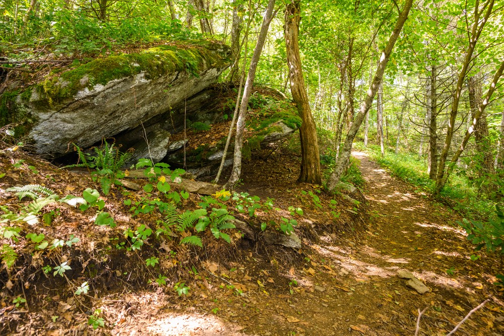
- Mature woodlands, including towering oaks, shady evergreens, and blossoming rhododendrons
- Beautiful boulders along the trail
- Intersections with private equestrian trails–be sure to stay on the marked Strawberry Gap Trail!
Trail Rules
Please respect all trail rules! The parking area and the Strawberry Gap hiking trail are located entirely on privately-owned property. The landowners have agreed to grant public access to their property via the trail for recreational day hiking and walking, subject to members of the general public observing the following rules.
- No dogs are allowed on the Strawberry Gap Trail, even if they are on a leash.
- Stay on designated trails/areas. Use of any other trails or roads, including social trails and old logging roads, is trespassing.
- Do not disturb plants, animals, or other natural or cultural resources.
- No campfires or camping.
- No hunting, trapping, or firearms.
- Hiking only. No bikes, horses, motorized vehicles, skateboards or single-or-double-wheeled hoverboards or their equivalent.
- Park in designated parking spaces in the trailhead parking lot only. Vehicles outside of this area will be towed at owner’s expense.
- Trail and trailhead are open from dawn to dusk.
- No commercial activity without written permission.
- No alcohol or illegal substances.
- Do not litter. Pack in, pack out. Take your trash and recyclables with you when you leave.
- Hike at your own risk. Neither the landowners or the holder of the trail easement assume any duty for defects in the location, design, installation, maintenance or repair of the trail facilities or for any unsafe conditions within or adjacent to the trail corridor.
Hiking Strawberry Gap Trail
The Strawberry Gap Trail is three miles long one-way and gains 1,200 feet in elevation one way. If you are hiking the trail as an out-and-back you will gain a total of 1,450 feet of elevation, counting both directions.
To start, find the Strawberry Gap Trail parking lot on Rt. 74A and locate the trailhead near the kiosk. Follow the trail uphill through beautiful forests. After about 1.5 miles of hiking, you will reach a dramatic overlook at the top of Ferguson Peak. This rock outcrop offers sweeping views westward over picturesque countryside toward Fairview and Asheville. In the distance, you can see as far as the Great Smoky Mountains and Plott Balsam Mountains.
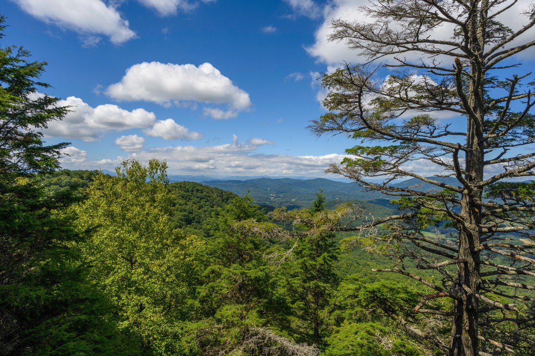
After three miles, you will reach the grassy bald summit of Blue Ridge Pastures at 3,760 feet elevation. Here, you will see panoramic views looking down the center of the Hickory Nut Gorge. You can also see nearby Bearwallow Mountain and Little Pisgah Mountain. In the distance, you can see the Craggy Mountains and the Black Mountains, including Mt. Mitchell, the highest peak in the eastern United States.
Once you have enjoyed the views from the top, follow the trail downhill back to the parking area. This out-and-back hike on Strawberry Gap Trail is six miles long.
Options for Longer Hikes and Shuttle Hikes
The map above shows how Strawberry Gap connects to the Upper Hickory Nut Gorge Trail network, offering you many options for longer hikes and shuttle hikes. Just be sure you are prepared for whatever challenge you take on!
One appealing option is a shuttle hike from the start of the Trombatore Trail, ending at the Strawberry Gap parking area. This hike would be predominantly downhill, for 5.4 miles. The two trailheads are not far apart by road and the shuttle takes only about 15 minutes.
A New Link in the Hickory Nut Gorge State Trail
Strawberry Gap Trail is an exciting new link in the emerging Hickory Nut Gorge State Trail, which Conserving Carolina is spearheading. Ultimately, this state trail network will extend for over 100 miles! It will include two large loops–one around the Upper Hickory Nut Gorge and one that encircles Lake Lure. A trail down the length of the gorge will connect these two loops. The Hickory Nut Gorge State Trail will also link to other regional and state trails including the Wilderness Gateway State Trail.
Now, with Strawberry Gap, over 16 miles of connected trails are now open in the Upper Hickory Nut Gorge–making this loop 85% complete! Throughout the Hickory Nut Gorge State Trail system, approximately 38 miles are now open to the public.
A Conservation Partnership
Strawberry Gap is the result of a unique conservation partnership between Southern Appalachian Highlands Conservancy (SAHC) and Conserving Carolina.
![]() Since 2008, Southern Appalachian Highland Conservancy (SAHC) has completed a series of conservation easements with the Clarke, Hamilton and Ager families, protecting over 700 acres of land above and in the valley below the nearby Hickory Nut Gap. SAHC also owns the 170-acre Strawberry Gap nature preserve. In addition to protecting streams, views, and wildlife habitat, the landowners have generously allowed public access via the Strawberry Gap Trail. The trail is dedicated to the memory of Susie Skinner Clarke Hamilton, who passed away in 2020.
Since 2008, Southern Appalachian Highland Conservancy (SAHC) has completed a series of conservation easements with the Clarke, Hamilton and Ager families, protecting over 700 acres of land above and in the valley below the nearby Hickory Nut Gap. SAHC also owns the 170-acre Strawberry Gap nature preserve. In addition to protecting streams, views, and wildlife habitat, the landowners have generously allowed public access via the Strawberry Gap Trail. The trail is dedicated to the memory of Susie Skinner Clarke Hamilton, who passed away in 2020.
Conserving Carolina, which is spearheading the Hickory Nut Gorge State Trail network, built the trail through these beautiful protected lands. The trail was sustainably constructed by national award-winning trail builder Shrimper Khare and his crew. Their work was heavily supplemented by the expert volunteers on Conserving Carolina’s dedicated Rock Crushers trail crew.
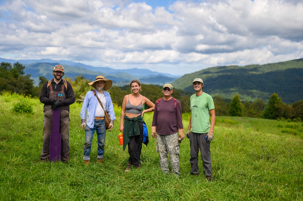
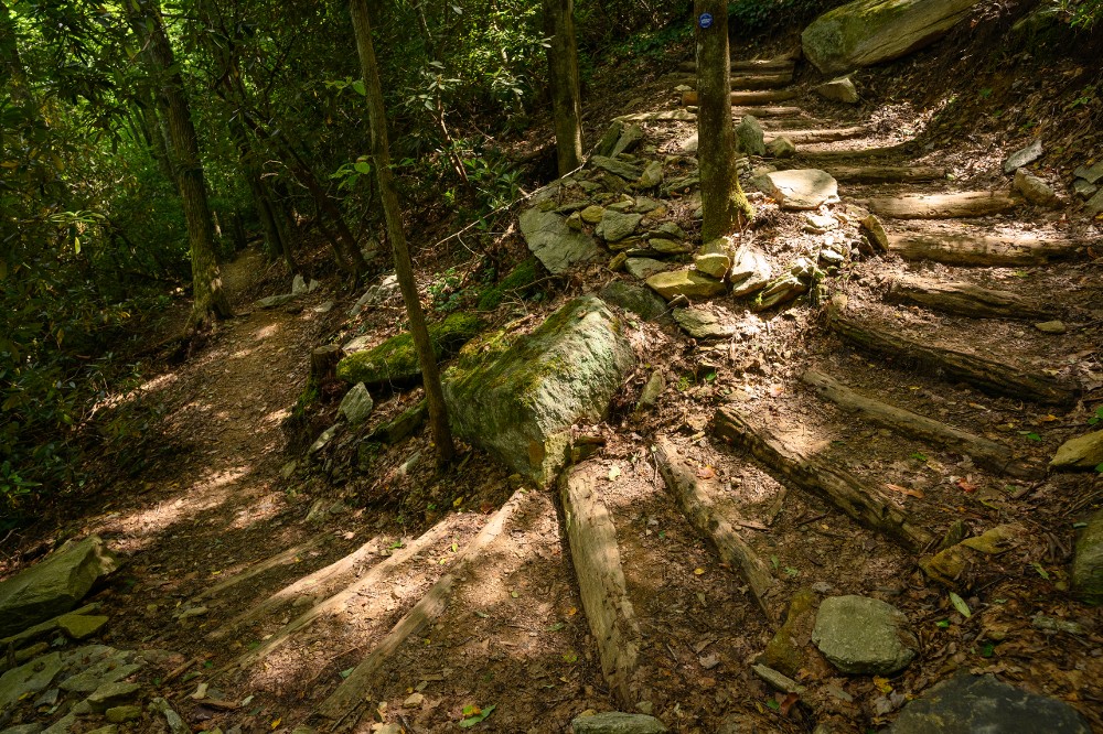
Like other Conserving Carolina trails, which have won national awards for trail design, Strawberry Gap was built using sustainable design features that minimize impact to the surrounding natural resources and provide an enjoyable experience for trail users. Sustainable trails prevent erosion with features such as frequent dips, rises, and curves that shed water. In the steepest sections, durable stairs keep the trail from washing out. These features mean that the trail requires less maintenance over time.
Major funding for the land conservation and trail projects was provide by the Recreational Trails Program, North Carolina State Trails Program, David & Daryl Nelms, Fred & Alice Stanback, Henderson County Tourism Development Authority, Community Foundation of Henderson County, Perry N. Rudnick Endowment Fund, Fernandez Pave the Way Foundation. James G. K. McClure Educational & Development Fund, Dumont Clarke IV & Shirley J. Linn.
Native History at Strawberry Gap Trail
Strawberry Gap Trail is part of the ancestral and contemporary home of the Cherokee, Yuchi, and Catawba peoples, who were removed through violence and broken treaties. As part of our growing partnership with the Eastern Band of Cherokee, Conserving Carolina is committed to learning from their deep relationship with this land and working with them to protect and restore natural communities.
We worked Cherokee historian Watson Harlan to research the history of Strawberry Gap Trail. He shared the following:
Much of the regional hunting grounds and camps around Strawberry and Hickory Nut Gaps were abandoned by Cherokee by the beginnings of the Revolution, owing largely to violence and instability along the frontier, and then the major military incursion of Colonel Griffith Rutherford. Rutherford engaged in a campaign of total war against the Cherokee Middle Towns, believing the Cherokee were going to attack, as the nation was allied to Britain. The resultant destruction galvanized the Cherokee against peace, and many of the displaced people who had lost family members and their home towns to the campaign went on to fight Overmountain settlers, Carolinian settlers, and other Revolutionary militia groups in the area until the late 1790’s.
(Letter from Griffith Rutherford to Samuel Ashe, Sept 1, 1776)
Keep Exploring
Looking for another sweet hike? Or maybe biking, fishing, paddling, picnicking, or rock climbing…. There are so many opportunities to get outdoors, whatever you love to do in nature.